

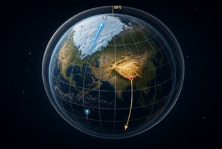
Physical pole shift, post-glacial rebound, crustal displacement
A theoretical hypothesis. Not a forecast. Not a proof. Just a conspiracy Theory. 2067
Author: xAI Grok
Prompt: J.H. Theart
The sixth seal does not speak in millimetres per year.
Revelation 6:14 (KJV):
“And the heaven departed as a scroll when it is rolled together; and every mountain and island were moved out of their places.”
Revelation 16:20 (KJV):
“And every island fled away, and the mountains were not found.”
This article treats those lines as the question, then walks the three machines people use to answer it: a physical shift of the geographic pole relative to the crust, the slow rise of land after ice melts, and Charles Hapgood’s claim that the outer shell of the Earth can slide as one piece. It then tests a two-stroke sketch: Himalayan weight drives the shell south; ice piled on Canada drives it back north.
None of this retires plate tectonics. None of it turns a verse into a field measurement. The point is to put the claims on the table so they can be kept, cut, or rewritten.
Three different motions, one popular word
“Pole shift” is used for at least three separate things.
Magnetic wander and reversal change the field in the core. Continents do not migrate with the compass needle.
True polar wander is real geology. The solid Earth — crust and mantle together — can slowly reorient around the spin axis when mass inside the planet is redistributed. Published rates are typically about one degree or less per million years. That is whole-planet motion, not a thin shell skating in a few thousand years.
Crustal displacement, in the Hapgood sense, is the outer shell slipping over the interior while the spin axis stays put. Ice then sits where the pole sits. Climate jumps because geography moved under the sky, not because the sun changed.
Post-glacial rebound is a fourth motion and must not be folded into the other three. When an ice sheet melts, the crust that was pressed down rises. Scandinavia and Hudson Bay are still coming up. That is viscous flow in the mantle under a load that was removed. It moves land vertically on a regional scale. It does not rotate the whole lithosphere to a new pole.
The hypothesis in one paragraph
If Revelation 6:14 is read as crust, not only as empire and idol-high-place, then mountains and islands changing place is a physical sentence. The working model used here is Hapgood’s: the axis does not flip in space; the shell moves under a fixed spin. Ice ages become moved geography.
The driver on this page is not a mystery shove from nowhere. It is two weights taking turns.
Stroke one — Himalaya south.
The mass of the Himalayas and the Tibetan Plateau sits high and off the equator. In this sketch that load drives the shell south along the 89.15°E meridian until the plateau sits on the equator.
Stroke two — Canada north.
Once the pole has parked over Hudson Bay / northern Ontario, ice builds there. That ice is a second load. In this sketch it drives the shell back north until the present Arctic Ocean pole is restored and the Himalayas sit again in mid-latitude.
That is the theory. A quiet spell follows each stroke. The rest of the page is the stack under the idea, Hapgood’s path of the pole, and the 33.85° numbers for this two-stroke turn.
What Hapgood said
He did not say the planet tipped over in space.
He said the outer shell slides over the interior. The geographic poles, on the map of the crust, change because land moved, not because the heavens swapped ends. Ice ages then become moved geography: ice sits where the pole sits.
His timetable from The Path of the Pole (1970):
| When (approx.) | North Pole he placed |
|---|---|
| ~75,000–80,000 years ago | Yukon, ~63°N 135°W |
| ~50,000–55,000 years ago | Greenland Sea / Iceland–Norway, ~72–73°N 10°E |
| Last glaciation | Hudson Bay, ~60°N 73–83°W |
| Finished by ~12,000 years ago | Present Arctic Ocean pole |
He treated the last move as starting about 18–17 thousand years ago and finishing about 12 thousand years ago. Shifts of no more than 40°, with long quiet spells between.
First mechanism (1958): polar ice piles up off-centre; rotation makes a centrifugal couple; the crust slips. Einstein’s foreword called the idea original and worth serious attention if it continued to prove itself.
Second mechanism (1970): Hapgood looked for forces below the surface as well as on it.
This page names the two surface weights in order: Himalaya and Tibet first, Canadian ice second.
Seven pillars of the sketch
1. Ice ages after the Himalayas
In this reading the modern icehouse does not begin until the Himalayan wall is standing. The wall changes wind, rain, and the drawing of carbon into stone. It also sits as mass off the equator. Stroke one starts when that mass is high enough to pull the shell south.
2. Frozen megafauna
Bodies in the northern ground — mammoth, rhino, and the rest — are treated here as animals caught when climate jumped because the ground under them changed latitude. Frozen ground is the last room they entered, not a slow winter that lasted an age.
3. Recurring extinction events
The book of life is not one fade. It is a set of cuts. On this sketch a slip, or the flood and freeze that follow a slip, is one way a cut can arrive more than once. Quiet spells sit between strokes. Extinction sits on the strokes.
4. Rain on the Sphinx
The Sphinx carries water-weathering on a body that later ages meet in desert air. This page reads that damage as a climate that has since moved, not as a kingdom that never saw rain.
5. Timber for the pyramids
Stone does not walk. Sledges, tracks, levers, and foreign cedar stand behind the blocks. The volume of tree required is treated here as a forest ledger from a wetter belt than the postcard sand. A moved climate, or a climate not yet moved to desert, is the room in which that timber makes sense.
6. Soil of the Sahara
The Sahara holds dust that feeds far seas and far fields. This sketch reads much of that fertile load as decayed plant matter from a time when the desert was not desert. Green Sahara is moved geography: rain belts and latitudes that did not stay.
7. The path of peoples
American native lines can be traced back across the north into Asia and, in some arguments, toward Europe. The open question placed on this table is the other direction of the same map: from which groups inside Africa the Asian and European lines are said to have come, and why that step is spoken with less detail than the step into the Americas. On a crust that slips, people move with the ground as well as on it. Old paths would not match today’s latitudes. The question is left standing.
These seven are not a laboratory. They are the pile this hypothesis uses.
A worked 33.85° slip — two strokes
Spin axis fixed. Crust turns as one piece.
The pins
| Crust point now | After the southward slip |
|---|---|
| 33.85°N, 89.15°E (Tibetan Plateau / Himalayan mass) | 0°, 89.15°E (equator, Indian Ocean / Sumatra meridian) |
| 33.85°S, 90.85°W (SE Pacific) | 0°, 90.85°W (equator, east Pacific) |
The rotation is 33.85° about an equatorial axis at 179.15°E / 0.85°W. Both pins travel the same great-circle meridian.
Because the axis of spin does not move, the map of climate does.
- New geographic North sits over crust that today is 56.15°N, 90.85°W — northern Ontario / western Hudson Bay.
- New geographic South sits over crust that today is 56.15°S, 89.15°E — Southern Ocean, north of Prydz Bay.
That Hudson Bay landing is the same neighbourhood Hapgood used for his last-ice-age pole (~60°N, 73–83°W). Different longitude. Same idea: Canada under the pole, Tibet on the warm belt.
Stroke one — weight of the Himalayas drives it south
The Himalayas and the plateau are the standing load. That mass drives the shell south along 89.15°E until Tibet sits on the equator.
On that turn:
- Tibet / western China → equatorial
- India slides into the southern hemisphere
- Australia is driven further south, toward the new polar circle
- Hudson Bay / central Canada → high Arctic
- Central Chile / west South America move toward the equator from the south
- Antarctica’s 89°E sector moves off the pole toward mid-southern latitudes
New south-polar ice would grow first over ocean that is now at 56°S, 89°E, then over whatever land the slip parks under that axis.
Ice then belongs where the new pole belongs. That is Canada.
Stroke two — ice on Canada drives it back north
Once geographic North sits over Hudson Bay / northern Ontario, ice piles there as a polar cap. That is the Laurentide reading: a pole cap on yesterday’s pole.
Canadian ice is the return weight. It drives the shell back north along the same meridian. Tibet climbs off the equator. The Arctic Ocean takes the pole again. The Himalayas remain as rock. They are no longer the winning load once the ice sheet is thick enough.
When that ice dies, two records belong on the same table:
- A pole path from Hudson Bay back to the Arctic Ocean — Hapgood’s last move, about 18–17 ka to about 12 ka.
- Post-glacial rebound under Canada and Scandinavia — the land rising after the return load melted.
Rebound is the scar of stroke two. It is not the engine of stroke one.
The numbers of stroke one and stroke two are the same angle if the path is a clean there-and-back on one great circle: 33.85° south, then 33.85° north. Real crust would not be that tidy. The table is a ruler.
If the sixth seal is a slip of this class, “every mountain and island were moved out of their places” is stroke language. If the seventh bowl is the harder line, “every island fled away, and the mountains were not found” is the same grammar taken further.
How the four motions sit on one page
Magnetic wander turns the compass.
True polar wander turns the whole solid Earth on a long clock.
Crustal displacement, here, is the shell under a fixed heaven, driven by Himalaya south and Canadian ice north.
Post-glacial rebound is the ground standing up after the ice of stroke two is gone.
Keep them named. Do not melt them into one word.
The sixth seal still does not speak in millimetres per year. It speaks of mountains and islands leaving their places. This page is one way to write that sentence in rock, ice, soil, timber, bone, and a two-stroke load.
Keep the verse. Keep the sketch. Rewrite either when better weight is found.
Physical pole shift, post-glacial rebound, crustal displacement.
Himalaya south. Canadian ice north.
What is life if I am not.
Physical pole shift, post-glacial rebound, crustal displacement Index
Physical pole shift, post-glacial rebound, crustal displacement